Airport Compass Calibration Pad Services
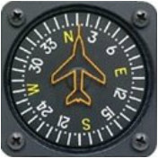 The magnetic compass is an essential navigation instrument in all aspects of travel but a very important back-up tool among the more sophisticated navigational instruments on large aircraft and often the primary navigational tool on smaller private and sport aircraft. All magnetic compasses are responsive to the earth’s magnetic field, but likewise subject to natural variations in the earth’s magnetic field and deviations occurring as a result of magnetic compass construction and surrounding aircraft body ferrous metallic influences, and therefore must be calibrated through routine checks such that the instrument can be relied upon for magnetic azimuth accuracy.
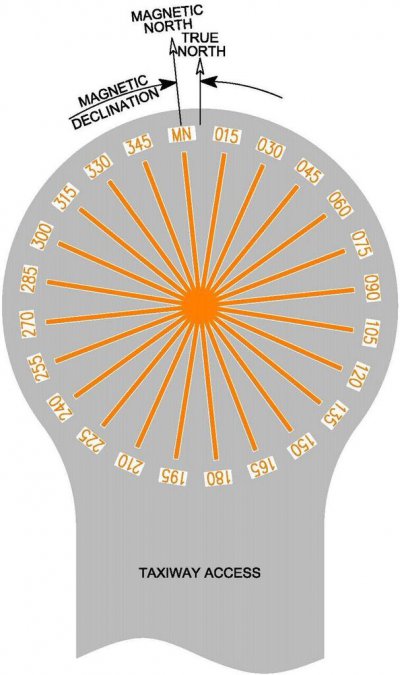
Private, municipal, and government airfield infrastructure may include an area used for temporary resident or guest aircraft occupancy for purposes of onboard magnetic compass adjustment, correction, and compensation through compass “swinging” procedures. Referenced as the compass calibration pad, or CCP, this area is a prepared paved surface in an accessible, yet remote, portion of the airfield upon which magnetic azimuths are marked in radial orientation at 15° or 30° arc increments from a center point. The magnetic azimuth markings on the pad, or compass rose, must be accurately oriented, identified, and depicted for aircraft reference. Pursuant to Federal Aviation Administration (FAA) standards and recommendations Advisory Circular AC 150/5300-13A, and Department of Defense (DoD) Unified Facilities Criteria UFC 3-260-01, an existing compass rose should be certified for accuracy at regular intervals of five (5) years or less or in the event that major construction occurs within 150 ft. of the center of the pad, and specific requirements must be considered for new CCP construction and compass rose marking.
 E. F. Thompson Geotechnologies, Inc. provides independent full service capabilities meeting the specific needs of private, municipal and military airport facilities. Whether a simplistic re-certification of existing compass rose markings or more involved preparation of a new CCP facility, our team of registered land surveyors and geophysics applications engineers can provide the necessary field instrumentation and technical expertise and consultation necessary to assure that that the airport CCP accurately depicts the earth’s magnetic azimuth orientation and markings for aircraft use and reference.
Compass Calibration Pad (CCP) Services
- CCP site planning and coordination with airport authorities
- CCP site selection reconnaissance and consultation
- Existing and new CCP Preliminary Total Magnetic Field site suitability surveys
- Existing and new CCP Magnetic Declination Field Surveys
- Measurement of existing Compass Rose markings and magnetic azimuths
- New CCP Compass Rose magnetic azimuth layout and placement of non-magnetic reference disc(s)
- Re-certification of existing Compass Rose or certification of new and replaced Compass Rose markings by a Licensed Land Surveyor registered in the applicable resident state
- Complete reports including CCP layout documentation and specification compliance
- Existing azimuth striping removal and re-striping/marking as may be required
Critical aspects of our airport services include the Preliminary Total Magnetic Field Survey and the Magnetic Declination Field Survey. These are separate surveys with each satisfying distinct objectives for accurate and dependable compass rose markings on the CCP.
The Preliminary Total Magnetic Field Survey is a m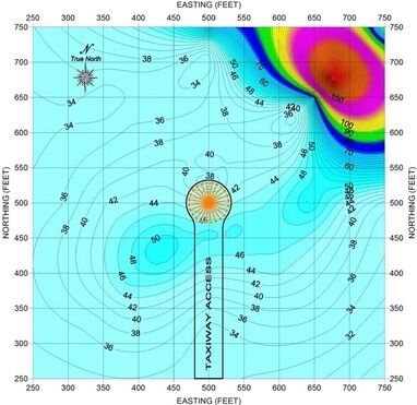 easurement of the horizontal component of the earth’s total magnetic field at specific points within and beyond the immediate dimensions of the existing or new CCP. This survey is typically performed with the intent to “screen” the site for local and isolated magnetic perturbations as may be caused by the presence of unseen buried or overhead features that would otherwise alter the magnetic declination accuracy, thereby assuring the area is geomagnetically “quiet”. Measurements are made using a portable Geometrics. G-857 Proton Procession Magnetometer at each of multiple grid-oriented established points. Whereas this instrumentation is easily deployed and data collected in rapid succession over the typically large area, this survey is used to efficiently determine the suitability of selected sites for new CCP construction or prior to re-certification of an existing CCP where new construction has occurred proximate to the pad area. Total magnetic field measurements are recorded (nano-Tesla, nT), data post-processed using statistical analysis with measured and applied diurnal variation corrections. Data is prepared as contour scale plats and results evaluated with respect to applicable threshold airport-specific, FAA or DoD specifications.
The Magnetic Declination Field Survey follows the determination of suitability of an existing or new CCP site by the Preliminary Total Magnetic Field Survey. The objective of the Magnetic Declination Field Survey is to measure the absolute difference between the True North meridian and Magnetic North meridian in degrees arc, this resulting value to be used in assessing the legitimacy of existing compass rose markings or need for placement of new markings upon an existing CCP, and assessing the correct azimuth orientation to be used for new CCP construction. In accordance with industry-accepted standards for the Distant Hub method, this survey involves the establishment of the True North azimuth by GPS and Total Station land surveying methods, followed by the deployment of a certified Wild-Heerbrugg New Model TO datum compass theodolite for direct measurement of the magnetic declination at each of multiple pre-established and grid-oriented points. This survey is typically time-intensive for accurate and comprehensive assessment. Magnetic Declination data is recorded, certified compass corrections applied, and data post-processed using statistical analysis with measured and applied diurnal variation corrections. Data is prepared as isogonic scale plats and results are evaluated with respect to applicable threshold airport-specific, FAA or DoD specifications. The absolute CCP magnetic declination value is statistically determined using site-specific compiled data.
In the eventuality that a selected site for a new or existing CCP is determined by our surveys to include unforeseen magnetic-field influencing anomalies, E. F. Thompson Geotechnologies, Inc. has the expanded geophysical capability to non-invasively search, locate, and assess any magnetic anomaly for consideration of possible removal or relocation. Our supplemental geophysical capabilities include ground penetration radar (GPR), electromagnetic conductivity profiling, and ferrous/non-ferrous metallic detection. Our instrumentation includes minimum annual calibration and certification as applicable.
Our deliverable product includes professional reports prepared to include the following:
Written report of procedures and services performed, statement of site suitability, magnetic declination, annual declination variation, and certification by Licensed Land Surveyor registered in the airport’s resident state.
- Identification and discussion of the significance of any magnetic anomalies as may be determined at the CCP location.
- Compilation of data acquired, statistical post-processing, and threshold comparisons.
- Scale plat layout of data points and existing surface civil feature improvements within the CCP vicinity.
- Scale plat layout with isogonic and contour depiction of post-processed data results.
- Reference calibration certification for applicable instruments and license documentation.